The xtremeteam reached Mt Shasta's 14,162 ft summit at approx 9:45 AM on 8/12/2011, maintaining their 100% success rate at summit attempts.
Planning the Climb
Although my June trek to the Mt. Marcy summit had enough challenges to keep it interesting, it only served to amplify my cravings for a bona fide thin air experience. Although I’d had my eye on Mt Rainier for a while, I decided I should go for something just a shade less technical for my first attempt at a +14,000 ft peak.
Less than an hour of web surfing landed me on Mt Shasta as the perfect candidate. The summit is 14,162 ft and they had a load of snow this year, so it would still be mostly covered even in August, which is when I could arrange to get away for a few days. I much prefer climbing on snow and ice Vs rock climbing or even rocky trails. It’s easier on the knees and ankles on the flatter sections and on the steeper sections you can usually just go right up at a steady pace, kicking in with crampons and ice ax Vs hunting and pecking for hand and foot holds on the rocks.
With the destination chosen I contacted fellow Xtreme Climber Milos who is usually ready to try pretty much anything I propose. As expected, he instantly agreed to join me on the trip despite the fact that he had never heard of Mt. Shasta, never been to California, and never been higher than around 10,000 ft before.
 |
| Pre-trip gear inventory |
Getting There
Mount Shasta is located in Northern CA, about 60 mi. from the Oregon border to the North and roughly halfway between the Nevada border to the East and the Pacific Ocean to the West. Looking at the map, Sacramento Intl, about 200 mi south on I5, seemed to be the closest major airport.
I booked a flight out of NY LGA for Wednesday, August 10 departing at 7:10 AM with a scheduled arrival time at SMF of 1:25 PM due to a two-hour layover in DFW. My plan was to drive straight up to Mt Shasta city and find a place to camp out for the night. The next two days would be spent climbing the mountain and driving back to Sacramento where I would spend my final night in CA before flying back on Saturday morning.
Both legs of the flight were on time and by around 2:30 PM we were headed north on I5 in my rented Chevy Aveo. Three hours and 210 miles later we pulled up in front of
The Fifth Season, a local mountain shop on the corner of Lake St. and Mt. Shasta Blvd where I planned to rent some additional gear we would need for the climb. After picking out helmets, ice axes, trekking poles and sleeping pads we headed over to the
Mt Shasta Supermarket to pick up some provisions. This consisted mainly of jars of peanut butter and jelly, a half dozen rolls to make sandwiches, a couple of bananas, two cans of Red Bull and some bottled water. Weight would be at a premium and I figured this would be plenty for the 30 hours or so it would take to complete the climb.
At the suggestion of the counter person at the mountain shop we rented a campsite over by Lake Siskiyou at
Reynolds Camp Resort. Since we would be roughing it the following night up at the Lake Helen base camp, I figured we’d splurge on a place with running water and flush toilets! My altimeter was reading about 3250 ft, which I hoped might go a little way towards acclimatizing a couple of sea level dwellers to the higher elevations.
 |
| Mt Shasta, looking ominous from downtown Shasta City |
Pre-Climb Preparations
After 5-6 hours of fitful sleep, I crawled out of my tent at a little after 6:00 AM local time. My Casio triple sensor was showing an outside temperature of 51F, which definitely got me wondering about what was in store for the next night at Helen Lake, over 7000 ft higher in elevation.
After dismantling our tents and rolling up our sleeping bags, we set about getting our backpacks ready for the climb. Although we had a pretty definite plan as to what we wanted to bring along, neither of us had ever gotten around to doing a dry run as far as actually seeing how it would all fit in the internal frame backpacks we brought along. The approach I chose that morning was to lay all the gear I wanted to bring on the picnic table and see if I could do sort of a mental jigsaw puzzle to visualize how it would best fit in my pack. After a little trial and error I managed to squeeze my lightweight sleeping bag into the bottom compartment, and in the upper compartment I fit the two 1.5 liter bottles of water I was bringing along, my
Black Diamond Sabertooth Pro crampons, three PJ sandwiches, two Cliff Bars, a can of Red Bull, and all my extra clothes; long hiking pants, extra wool socks, underwear, water wicking short and long sleeve shirts, long & short sleeve cotton shirts, fleece soft shell jacket, Goretex outer shell. In the side compartments I added my GPS receiver, Android, headlamp, waterproof gloves, waterproof pants (essential gear for the anticipated glissade back down the mountain), a tube of SPF 50 sunscreen, and another 20 ounces of water. That left just my helmet, ice ax, tent and sleeping pad, all of which I managed to strap to the back of the pack.
It looked like the plan was coming together perfectly until I went to lift it onto my back for a final check out. Let’s just say it felt way heavier than I expected. Dropping it back on the ground, I stared at it trying not to think about the fact that I was going to have to carry this thing almost 14 miles round trip with an elevation gain of over 7500Ft! Looking streamlined and svelte just moments earlier, the pack now appeared to my eyes as bloated and ponderous. Although I probably had roughly double the gear required for your average Navy Seal middle of the night Bin Laden raid, I really couldn’t think of anything I could jettison. With the decision made to go with what I got, there was no point hanging around the campground any longer so we headed into town to get breakfast and pick up our climbing permits.
The ranger station is right in town on Alba St, and it is mandatory for all climbers to register there before making a summit attempt. The $20 fee is a veritable bargain when you consider that it includes a search party that will attempt save your life if the rangers see your vehicle still at the parking area past your stated return date.
The Climb
With permits in hand it was finally time to get out of Dodge, so we drove a couple of blocks out of town and picked up the Everett Memorial Highway headed East. After eleven miles of steady climbing we arrived at the Bunny Flats parking area and trail head (elev 6,900 ft). Kicking off my running shoes, I put on a pair of thick wool hiking socks and laced up my
La Sportiva Trango Extreme Evo Light mountaineering boots, which I would be giving their first real road test. After a final coating of SFP 50 on all exposed body surfaces, I hoisted my pack and hit the trail.
The trail from Bunny Flats to Horse camp is a well maintained 1.7 miles, with a vertical gain of about 1000 ft. This section would turn out to be, by far, the easiest part of the climb. Nevertheless, I was only minutes into it when it became clear that I was in for an ass kicking. Breakfast didn’t make my pack feel any lighter and I realized that the clip was missing from the chest strap, leaving it inoperable. This caused the shoulder straps to dig into my mastoids even more since no weight was distributed to my collarbone area. A hiker we met on his way down suggested we ask Barbara, the caretaker of the Sierra Club hut at Horse Camp if she any spare parts I could use to jury rig it. When we trudged into Horse Camp an hour or so later, it was deserted except for two climbers who, having summited early that morning, were resting up and quaffing down the delicious water from the mountain spring in preparation for the final leg back to the parking area.
I dumped the remainder from my 20 oz bottle and re-filled it with the spring water to try a sample. Well, not only was this the most delicious and refreshing water I’d ever tasted in my life, but it triggered the depressing realization that I’d just hauled 3.5 liters (12 LBS) of store bought water up 1000 ft for no reason other than stupidity.
About that time, Barbara, the Sierra club caretaker, came up the trail with a backpack full of provisions, having gone into town earlier in the day to re-stock. When I showed her my damaged chest clip, she graciously removed a strap from her personal pack and offered to lend it to me until I returned from the summit the next day. That worked out perfectly and put me in a little more positive mood to tackle the next leg up to Helen Lake.
 |
| Notice the rock with the big white letters reading "Summit Trail" in the lower right? |
After dumping our store bought water and refilling our bottles from the spring, we hoisted our heavy packs back on and headed out on the summit trail for base camp at Helen Lake. The only problem was, instead of taking the trail marked in big white letters “Summit Trail” we took a trail off to the right that eventually petered out in a gulch about a half-mile later. Suspecting that this was not the famed “Olberman Causeway” I called a halt. Since this stretch involved some difficult terrain and a fair amount of elevation gain, I was reluctant to just backtrack and write off the whole effort. Using my best Nate Silver game theory logic, I decided that I would hedge my bet by dropping my pack and jogging back to Horse Camp to get directions just in case we actually were on the right trail.
Explaining as best I could where I had left Milos and the packs, Barbara said that we might be able to go overland and meet up with the Olberman trail but, no doubt skeptical of my pathfinder skills, suggested we just come back and take it from the top so to speak. That sounded like a good idea until I started to jog back up the “Not the Summit trail” to advise Milos of our situation. Apparently jogging downhill is a lot easier than uphill, for by the time I reached him I realized we had hiked a lot farther than I had remembered. I informed him we were headed overland in a Northwesterly direction to intercept the real summit trail. It involved climbing up and down a series of minor gulches on a surface of loose volcanic rock, but sure enough we did meet up with the famed causeway, a stone path approx .5 mi long built by Mac Olberman, the first caretaker of the Sierra Club hut. Most of the stones are monsters that he levered into place and buried to create something akin to a staircase up the mountain. Because we intercepted it close to its end, a short distance later we hit a steep incline of loose rock and then the real climbing began.
With my altimeter reading about 8600 ft, we started working our way up the slippery switchbacks, stopping every 5-10 minutes for short breaks of a few seconds where I would lean over on my trekking poles and let my pack rest on top of my back to give my shoulders a break from the straps that seemed to be digging ever deeper into my mastoids. Eventually we reached an area called 50/50 Flat, where one of the climbers we met at Horse Camp suggested we could camp if we didn’t feel like going all the way to Helen Lake that day. There were a couple of decently flat tent sites there, but it was way too early to break for the day. A little beyond 50/50 we hit the snow field that filled the gulch all the way up to the Red Banks, which was as far up the mountain as you could see from that vantage point. With the sun shining hot, the top inch or so of snow was fairly soft so we decided to leave our crampons packed since we were getting decent enough traction without them. The main difficulty was the deeply cupped contour of the snow, the result of a couple of months of uneven melting. It was like walking up a gigantic egg carton, with each step landing on a surface that was either at a sharp angle up or a sharp angle down. I tried to hop from crest to crest, but this led to a couple of near slips which put serious strain on my leg muscles due to the extra weight of my backpack. The best strategy seemed to be to look for the flattest spot and stamp your foot down hard to dig in a little on each step. We took turns leading, since the person following could make use of the leader’s footprints to walk in a more normal mode.
I had been noticing a solo climber following us up the trail and when we came across a couple of large boulders poking out of the snow that offered a dry place to sit, we took a break and waited from him to catch up. He introduced himself as Mike from the Bay Area. After a failed attempt two years earlier with his brother-in-law, he was back by himself to try again and was counting on hooking up with some other climbers to summit with. He had promised his wife that he wouldn’t try to summit on his own so I invited him to join our party and guaranteed him in 24 hours he would be calling her to report a successful climb.
While BA Mike was regaling us with a sort of show-and-tell of all the new gear he had purchased for this climb, I noticed several tired looking figures working their way down the snowfield towards us. They turned out to be a couple and their two young sons who had attempted a one-day climb. Leaving the parking lot around midnight, they had gotten as high as the Red Banks; a particularly steep section at 13,000 feet, before calling it quits. The older son, 14, admitted in an exhausted sounding, matter-of-fact tone that he couldn’t go any higher. This wasn’t the most encouraging message to be getting, but I factored in that most 14 year olds simply haven’t figured out just how far you can push the human body when you need to. After a brief chat, we hoisted our packs and resumed our climb up the snowfield.
 |
| BA Mike with the Crocodile Dundee hat, me in the middle and father and son climbers on right |
From about the time we hit 50/50 flat I had been able to make out the outline of a small yellow tent pitched on a rocky outcropping high up the mountain, at what I assumed was Helen Lake. As there is no trail to follow on the snow, I used the tent as a landmark and as the hours passed it came closer into view. Gauging distance on mountains is always a challenge, and on snow it is particularly deceptive. I got to a point where I would look up and estimate the tent to be only about 300 yards away, climb for another 20 minutes, look up and it would still seem to be about 300 yards away. It took 3 or 4 iterations of this to arrive at the base of the ledge below where the tent was pitched, which finally was about a true 300 yards away. Seeing that a straight on approach would be an impossibly steep climb with our 40lb packs and exhausted legs, we decided to work our way to the left and angle up in the direction of Casaval Ridge and then cut back across to our right to reach the campsites. Struggling up what we hoped was our last hundred feet of elevation gain before we could finally drop these damnably heavy backpacks for the day, we climbed the ridge and circled back to our right towards a flat looking section on the snow. The yellow tent I had been aiming for all day was nowhere to be seen and a sense of dread was creeping into me, fearing that I’d gotten sidetracked for a second time that day. As I stood there puzzling the situation, BA Mike came up from behind and announced, “This is it! We made it to Helen Lake!”.
Whether it was delusions brought on by low oxygen or simply wishful thinking, I’ll never know, but he continued, “these campsites are great, I’m taking this one!” as he pointed to a large 3 foot deep depression in the snow where you probably could set up a tent and find some protection from the winds if you absolutely had to. Meanwhile Milos stumbled up the last few feet on tottering legs, and just dropped his pack on the ground and sat down on it without saying a word.
Although the idea of getting this heavy pack off my aching shoulders right then and there had a certain appeal, I figured I better continue on and find the real campsites before either of these guys decided to actually start unloading their packs in the middle of the snow field. A few exhausting minutes later I climbed up a small embankment and spotted not only the yellow tent, but two guys busy packing up their gear on a flat rocky area sticking out of the snow. As I got closer I noticed the area was sectioned into a series of oval campsites, each surrounded by a low stone wall about 24 inches high that served as a wind break I assumed. I headed over to greet the two climbers and get any useful information they could pass on. In their fifties with Eastern European accents, they told me they had reached the summit early that morning and had taken a nap after getting back to base camp to prepare for the final descent. One of them recommended I take their campsite, since in his opinion it was the best of the dozen or so up there. Desperate to relieve my shoulders from their burden of the last 6 hours, I happily dropped my pack right there without deliberation. They explained that the yellow tent was actually a store of emergency supplies that the rangers had placed there. After a chatting a few moments more, I headed back down the embankment to summon BA Mike & Milos.
After re-hydrating with water and relaxing for a few minutes, we set about erecting our tent and laying out our gear so we could re-pack the minimum necessary for the summit climb.
 |
| Futile search for a mobile signal at Helen Lake |
I removed my boots and perched them on some rocks hoping that the steady breeze and remaining sunlight would dry out the insides that were pretty damp from sweat. My heels had been stinging for the last few hours, and when I peeled off my socks they looked really red, but the skin was still intact. I made a mental note to remember to cover them in duct tape as soon as I woke up the next morning. Carrying along a mini roll of duct tape to cover blisters was a great tip I picked up from a fellow climber on Mt Hood back in ’08 when I got really ripped up in a pair of rental mountaineering boots.
With my sore feet feeling liberated in the cool breeze, I sat back on a stone seat and ate the 2nd of my three P & J sandwiches, awestruck by the incredible views.
Around 4:30 PM I spotted a tall, lone figure working his way up the right (Sergeant’s Ridge) side of the gulch. About 45 minutes after he disappeared behind the rocky outcropping that blocked my view of the middle section of the gulch, he reappeared, coming over the top of the crest of the Helen Lake camping area. As I watched, he navigated around the windbreaks until he reached the site immediately adjoining ours, whereupon he unceremoniously dropped his large pack to the ground and just stood there in his sweat soaked shirt for a few moments before announcing “that was the most physically demanding thing I have ever done in my entire adult life”. Interestingly, not only did he physically resemble a younger Bruce Dern, but also his voice was a spot on impersonation of Dern’s dry, monotonic delivery. I wondered if I was the only one who noticed that.
After re-hydrating and changing into dry clothes he introduced himself as Curt from the Sacramento area. It turned out this would be his third attempt to climb Shasta, the first one scuttled at 13,400 ft when his partner succumbed to altitude sickness and the second one halted much lower when his guide turned back due to reports of white out conditions at 10,000 feet coming in on his radio. Since he was climbing solo this time, I got the impression he was fulfilling some kind of pact he’d made with himself to get to the top of this mountain or die trying and he didn’t want any guides or friends around who might talk him out of it if things got rough. I also happened to notice that most of his gear seemed to be brand new, which I thought was a little strange for someone who did as much climbing as he claimed, but I let it pass without comment.
 |
| Looking down from Helen Lake Campsites |
I mentioned we’d be leaving around 3:00 AM for the summit and invited him to join us, throwing in my usual cocky guarantee of success. He seemed relieved to have found some partners for the much more dangerous upper section, and I figured that like BA Mike (and myself for that matter), he had made some promises to his wife about not risking being caught on the mountain alone. It wasn’t until much later, during the descent, that Curt loosened up enough to confess that he had told his wife he was on a business trip to visit a customer. He didn’t’ go into detail for the reasons behind his deception, but any reasonable guess would probably be about right. That also explained the new equipment, as he could only smuggle a limited amount of gear into his car without his wife noticing, forcing him to buy replacements on the drive up.
Around 7:15 PM the sun was getting low and the temperature was dropping fast, so I quickly went about re-packing my bag for the early morning departure. There wasn’t too much to pack actually since I would be wearing virtually all my clothes in the frigid morning air. That left a 1.5 liter bottle of water, my last P & J sandwich, a couple of Cliff Bars, sunscreen, baseball cap, GPS, waterproof pants and my empty crampon bag (see notes).
Although I was fairly certain that the next several hours would only worsen my sleep-deprived state, I climbed into my lightweight sleeping bag to get what rest I could. It was a fitful night due to rocks poking through my thin sleeping pad and the continuously dropping temperatures which required me to put on additional layers of clothing every hour or so. Nevertheless, I did fall asleep at some point and was in the middle of a dream, re-living a surreal version of an experience I had at age 12 where I fell through the ice at the edge of a canal off the Great South Bay on Long Island. Chest deep in the freezing water, I struggled to climb up the embankment but my skates kept sinking into the wet sand, causing me to panic at my lack of progress. I could hear someone calling me “Mike, Mike, get up”. As I snapped back to consciousness I realized that it wasn’t my boyhood friend Jackie Lloyd reaching his arm down to pull me out of the cold water, but BA Mike calling me out of my cold tent to let me know it was already after 3:00AM. We had to get going so we’d make it past the Red Banks before sunrise to avoid playing dodge ball with the grapefruit sized boulders that would start dropping from the steep section as they melted out of the ice.
My Casio was showing a cool 48F inside my tent as I quickly removed the cotton shirts I was sleeping in to add two layers of water wicking under shirts, my fleece jacket, and Gore-Tex outer shell. After covering each blistered heel with a 5 inch strip of duct tape I put on fresh socks, knocked back 3 aspirin with a can of Red Bull, slipped on my headlamp and climbed out my tent. I looked around to to see both Mike & Curt standing nearby fiddling with their gear in the dark. Between my freezing fingers and the difficulty of working in the dark, it took another 30 minutes or so to double check all the equipment and get my boots and crampons properly fastened, but at 3:54AM we stepped out onto the snow to start our final ascent.
The previous day I had suggested we chart an initial course between two rocky outcroppings to the right, since that seemed to offer a more constant angle of ascent versus heading straight up the middle which looked to be practically flat for several hundred meters before angling steeply upward. It was a cloudless night with a full moon, so we were easily able to pick out the dark rocks against the white background. At this point we were using trekking poles, since it was not overly steep and the poles provided a lot more stability on the uneven surface than an ice ax. Further up the mountain we would encounter the “Red Banks”, a prominent orange palisade of welded pumice with a series of steep ice filled fissures, often referred to as chutes because braver types launch their downhill glissades from the top of them. Navigating this section requires aggressive use of your ice ax and crampon toe points.
Far up the mountain we could see two lights moving up a route to the left of the “Heart”, a large heart shaped bare spot just below the Red Banks. At one point I thought I spotted a 3rd light on the right side of the gulch, but as I was mostly focused on looking where I would place my next step to maintain balance and minimize the stress on my ankles I wasn’t looking up much to see if it reappeared.
Taking the lead position, I looked back every 5 or 10 minutes, happy to see that no one was dropping too far behind. Whenever it looked like someone was lagging a little too much I would stop and let them catch up. As Yogi Berra might put it, 90% of any physical endeavor is mental and it was important to avoid letting any discouragement seep into the team’s psyche. BA Mike seemed to be doing particularly well on this section. Earlier he had told us how he’d gotten pretty sick at 14K FT on Mt Whitney, so for this climb he got himself stoked on Diamox and it seemed to be working pretty well for him.
The higher we climbed the steeper the incline became, but by the time we reached the bottom of the Heart the first signs of sunlight were starting to creep over the top of Sergeant’s Ridge to our East, providing additional motivation to keep moving before the rocks started falling.
 |
Looking up from base camp at Helen Lake - Altitude 10,400 ft
|
As dawn broke I spotted a lone figure a fair distance above me, working his way up to the Red Banks. He was moving pretty slow, taking frequent breaks and I assumed his headlamp was the 3
rd light I had spotted a few hours earlier. I was gaining on him pretty quickly and by the time I got within 100 meters of the Red Banks he was resting on small rock ledge that provided a somewhat flat place to sit on that steep section. He watched me approach until I was about 40 meters away before rolling off the rock and moving up the icy chute at a surprisingly fast clip. I took advantage of the vacant perch to take a break and wait for the others to catch up. After advising everyone to put on helmets and replace their trekking poles with ice ax, I took off up the chute myself. My strategy on these really steep sections is to go as fast as I can for about 10 meters, catch my breath and repeat. My working theory is that these short bursts will rely on anaerobic energy therefore the thin air will have no impact on the effort other than taking a little longer to recover in between. From the bottom of the chute it didn’t look too far to the top of the ridge, but in reality the undulating slope hid the actual ridgeline until I got within 30 meters of it. In the end it turned out to be at least four times as high as I originally estimated. Finally emerging onto the top of an almost flat plain I spotted two guys resting against a large boulder about 200 meters away where the snow ended and the expanse of black volcanic scree that stretches up “Misery Hill” starts. I’m not sure why some sections are snow free, but I wondered if it has something to do with thermal activity from the volcano. In recent centuries Mt. Shasta has tended to follow a pattern of erupting every two hundred years or so, the last known eruption occurring in 1796.
 |
| That's me leading the way to Misery Hill |
I headed over to greet the two climbers who confirmed it was their headlamps we had spotted tracking up the left side of the “Heart” in the darkness. They were in the area for a birthday party and decided at the last minute to do a one-day ascent of Shasta. Like the family we met on the way up, they left the Bunny Flats parking area around midnight, but were having much better luck with their climb.
About 15 minutes later, the other three members of my party came over the top. I waved to them, but they headed over to another boulder much closer to where they were and dropped their packs there to rest. That’s when I noticed that sitting against that same boulder was the climber I had seen earlier at the base of the Red Banks. While I waited for them to re-join me, the birthday party duo threw on their packs and headed up Misery Hill. After a good break to recover from the steepest part of the climb, we resumed our climb, now joined by Pat from Redding. I christened him “The Dude” because of his quintessential laid back California baditude.
The stretch from there to the summit involved an elevation gain of about 750 feet and was more of a hike than a climb. Removing our crampons and switching back to trekking poles, we trudged up the loose scree on Misery Hill. At the top of the hill we encountered another fairly flat snowfield that led up to the base of a short, steep cone that rises a couple of hundred feet up to the summit. Although it was a pretty steep and slippery mix of rock and snow, I was able to work my way up it without crampons and in about 15 minutes I was saying hello again to the birthday boys who were just about ready to head back down.
 |
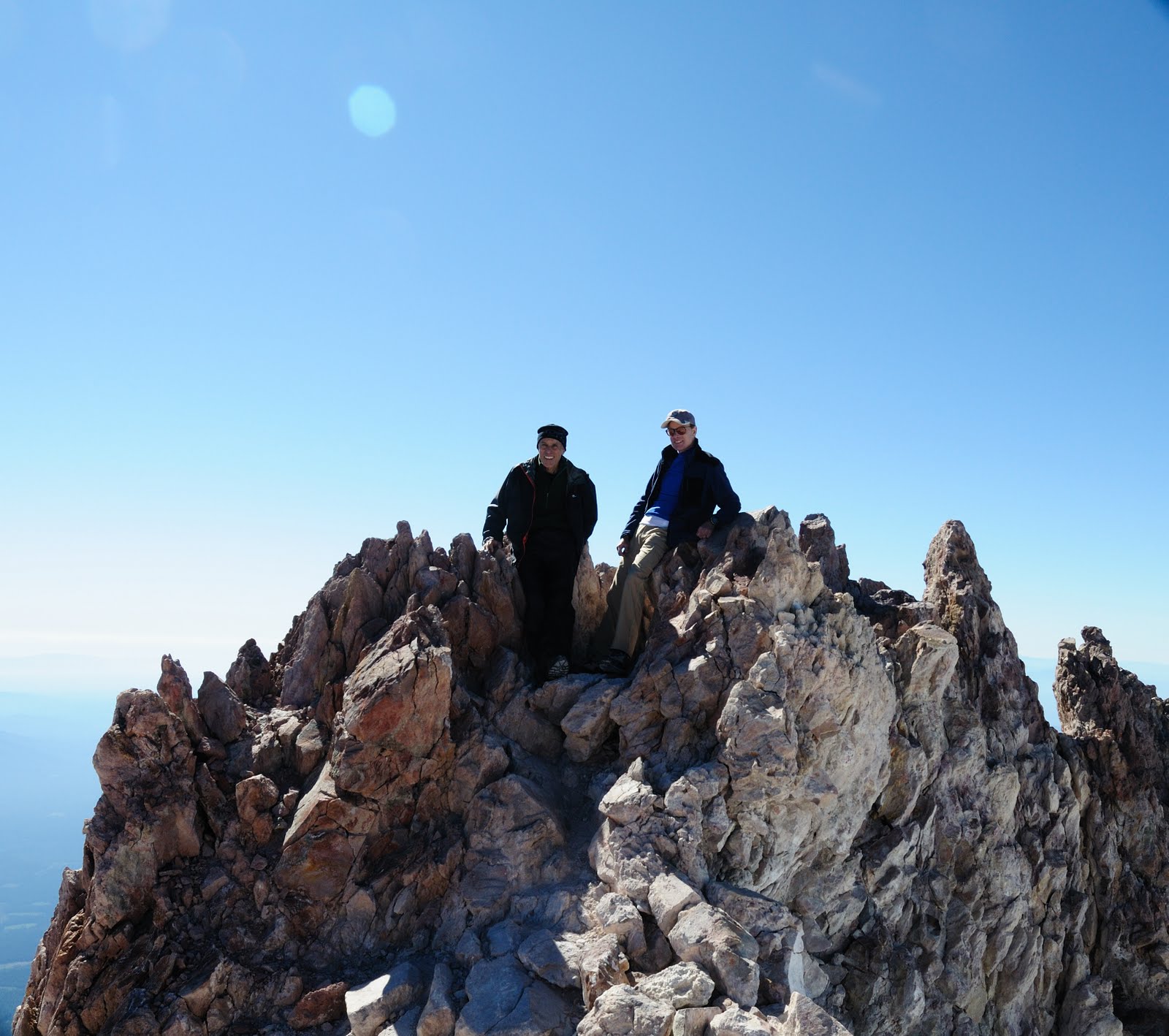
| Savoring the view from the summit |
The other three were only minutes behind me and we spent about 45 minutes hanging out there, signing the summit register, taking the obligatory pictures of each other standing on the small turret like projection that represents that actual highest point on the summit dome, and just enjoying the satisfaction of the moment.
 |
| Obligatory Summit Photo |
 |
| Sacramento Curt signing summit register as Birthday Boys start descent |
 |
| "The Dude" |
 |
| Looking down from summit |
The Descent
Going down was vastly easier than going up, at least as far as getting to base camp. It was a pretty easy walk back to the top of the Red Banks, although there was some slip sliding on the loose scree coming down Misery Hill. Pat, who had climbed Mt Shasta a couple of times before, recommended against descending the chute we used to come up, feeling it was a little too steep to glissade down and suggested we try one further to the East which he thought would have a milder slope. When we approached it, it looked even steeper to me, but because it curved to the left it was difficult to tell for sure. Volunteering to go first he lowered himself into the glissade chute and used his ice ax to ease down a few meters to get a better view of the glissade path. Quickly he announced that no one should try to slide down as it would require threading the needle between a couple of rocky towers about 300 feet down. Because of the shape of the chute I couldn’t see what method he used to get down to the bottom near the towers, but somehow he made it without losing control. Sacramento Curt announced that he was going to climb down and not even try glissading until he got much lower. Putting his crampons back on and ordering the rest of us to stay put until he was safely out of the way, he started down backwards using his ice ax. Just before he disappeared from sight around the curve I saw him slip and go shooting downward. I couldn’t see where he ended up, but I figured whatever happened to him we had to get down either way. I had already put on my waterproof pants to keep my butt from freezing during the glissade, so I went next figuring I would hug the edge where the ice didn’t look as slick and I could also grab onto the rock walls to keep from slipping if necessary. That didn’t work out so well as in the first 15 feet of so I struggled mightily to keep to slipping free several times. I managed to wedge myself under a rock overhang so I could re-think the situation, wondering whether I should risk trying to climb back up to put on my crampons or hope that I could control my descent at least long enough to get a clear shot at glissading between the rock towers below me. While I was thinking, BA Mike put his crampons back on started climbing down. He made it a little further than Curt before he also lost his grip and went flying down the chute. Down below Pat was hollering, “Self arrest, self arrest”. Mike had admitted earlier that his only “experience” in self-arrest technique was watching a YouTube video, so I’ll admit I had pretty low expectations as I watched him accelerating downward. Amazingly about 100 feet before he would have slammed into one of the towers he rolled over onto his stomach, yanked in his ice ax which he had strapped to his wrist (a dangerous practice with potential for self impalement), and executed his own YouTube worthy self arrest maneuver. He was still BA Mike, but the BA now stood for “Bad Ass”!
Meanwhile MIlos had lowered himself into the glissade chute and was trying to do a controlled descent using his ice ax. I suggested he might want to re-think that but within a few seconds he was hurtling out of control down the chute as well. Again Pat hollered “self arrest, self arrest”, but I had even lower expectations this time since I was pretty sure he had no idea what that even meant! About halfway down he lost his ax, but improvising on the fly he dug his heels into the softening snow and managed to plow up enough of a pile to bring him to a near stop as he approached base of the chute where Pat and Mike grabbed him. I proceeded to lower myself with particular caution, determined to retrieve Milos’s rental ice ax on my way down.
 |
Milos on left, Me on right, Pat and Curt in distance behind us.
The summit cone looks deceptively close in this photo |
Successfully making it down to where the others were waiting, I could see we now had a clear shot almost 3000 feet down a glissade path back to base camp. Pat reviewed the proper ice ax braking technique one more time and we excitedly launched ourselves down about ten seconds apart.
BA Mike, who'd been filing periodic, documentary style reports into his mini-camcorder, showed a knack for improvisation here. Gripping the mini-cam between his teeth to record the ride down, he rushed towards a destiny certain to include either a YouTube Award or a Darwin Award, or possibly both if the coroner could dislodge the device from the back of his skull.
It was an exhilarating ride down the first 1500 feet or so, but below that the softening snow at the lower altitudes was gradually scrubbing off our velocity. I finally ground to a halt at the flat section about 300 meters from base camp. I was feeling pretty rested at that point, so rather than get out my trekking poles to navigate the deeply cupped snow surface, I decided to break into a sort of run the rest of the way, leaping from crest to crest to keep my balance. The other guys probably thought I was going crazy or something, but it got me back to camp several minutes ahead of them.
 |
| Packing up for the climb down |
Having drunk the last of my water a while back, I was counting on an experiment I was trying for the first time working out. The previous evening I had walked out onto the snowfield and chipped enough of the hard snow to fill one of my near empty water bottles about halfway up. I left it out where I hoped the sun would heat it up enough the next day to melt. The plan basically worked, but the water had a terrible powdery taste, nothing like the spring water we enjoyed back at Horse Camp. Nevertheless, it was wet and I was thirsty, so down it went.
After packing up our camping gear and hoisting up heavy packs, we started the final ~3.5 miles back to the parking lot. At Curt’s suggestion we decided to hike east to Sergeant’s Ridge and avoid some of the uneven snow by descending the first 700 feet or so on the bare ridgeline. In truth the slippery scree turned out to be at least as challenging as the snow and the uneven slope put lateral forces on my legs that were really starting to take a toll on my groin muscles. Although I had by far the easiest time of it on the way up, advantaged by my runners frame and aerobic training, the tables were turned on the way down with the bigger guys finding it easier to control their descent on these steep slopes while carrying 40lb packs. Careful placement of feet and trekking poles was required to avoid being thrown off balance by a pack that was close to 1/3rd my body weight.
By the time we reached Horse Camp we were all hot, thirsty and exhausted. I was finally able to pick up a cell signal to call my wife and tell her to hold off euthanizing my six cats, which she threatened to do if I left her alone to care for them. I also confessed that I was so tired and my shoulders were so sore that I was uncertain that I would be able to make the final 1.7 miles back to my car unless I just abandoned my backpack right there and finished the hike carrying nothing but my car keys. Overhearing me, Barbara suggested I camp out there for the night, but I had a plane to catch the next morning and I didn’t want to count on getting up early enough to complete a 5 hour drive in time to make it. Besides, I really, really needed a shower!
After downing several aspirin and at least 2 more liters of the delicious spring water, I loaded the damnable pack onto my back one more time and pointed myself at the parking lot trail. The trail, which I remembered as being somewhat challenging on the way up, now seemed laughably easy. I guess it was just not being mentally adjusted to carrying a heavy backpack that made it seem hard at the time, because compared to the steep, slippery, and incredibly uneven surfaces we had covered since then, it was a perfectly groomed wide dirt trail, with a gentle slope on most sections. Being exhausted, it still seemed like an awful long 1.7 miles of course, but by around 3:30PM I was back at the car gently peeling the duct tape, along with a fair amount of skin, off my heels.
After some incredibly slow service at the Black Bear diner, which was overrun with senior citizens that evening, we hopped into the rented Aveo and pointed south on I5. A long 5 hours later found me checking into the Homewood Suites - Sacramento Airport where I took one of the most satisfying hot showers of my life before passing out between clean sheets to sleep more than 3 hours straight for the first time in four days.
 |
| View of Shasta from Rite-Aid parking lot on Lake St in Shasta City |
Sent from my LG phone
Epilogue: Obviously this climb involved some major compromises of the first two tenets of the XtremeTeam mission statement to "Travel light, travel fast, and don't be afraid to make it up as you go along". By way of explanation, since we were laying out some serious money for our last minute airfare and would only get one shot at this, I felt compelled to put a priority on guaranteeing that we would make it to the top above all else. While it was entirely possible, even likely, that a one day ascent would prove easier than the conventional two-day-haul-your-heavy-pack-to-base-camp approach, it left less margin for error if our pace was slowed by bad weather or trouble handling the altitude. The two day strategy meant you work really hard at the lower altitudes (7K ->10.4K ft), but at the higher altitudes (10.4K->14.2K ft) you can move pretty much as slow as you need to and still be sure of making it back before dark on the second day.
As it turned out, I was being over cautious, as we had no problem with either weather or altitude and I am certain that had we done a non-stop climb, I would have felt a lot less sore and exhausted when it was over. In the whole scheme of things though, the only principle that mattered was the principle to just stick with it until you succeed. We made it to the top and got some great photos to remember it by.
 |
| Little known fact; crampons not allowed on plane. | Had to check luggage. |
 If all goes according to plan, we'll be live blogging from the summit at around 7:00AM on July 31, 2012.